
DEVON RUSSELL
Increasing the Pipeline to Careers Supported by Geospatial Technology through...
NSF Awards: 1464677
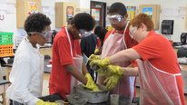
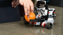
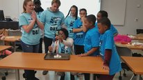
Geospatial technologies (GST) have an ever-increasing presence in today’s industries requiring workers to understand the operation and advantages of GST. In an effort to increase the pipeline for student interest in geospatial studies, Mitchell Technical Institute (MTI) created curriculum and training for K-12 educators to implement GST into the classroom. MTI has provided four, four-day workshops for over 80 K-12 educators to teach them the operation and theory behind Global Position Systems (GPS), Geographic Information Systems (GIS) and unmanned aerial system (UAS), commonly known as drones. The educators were provided with curriculum and ideas to implement GST into STEM and other disciplines. Along with providing resources, MTI saw a need to help schools attain geospatial technology. Each attendee of the workshop received a GPS-enabled tablet, and most recently MTI has launched a drone checkout program. The program allows schools to check out a drone for a set period of time, as well as additional training and resources. Workshop resources, training materials, and curriculum have been made available for download to K-12 educators along with the ability to check out a drone from Mitchell Technical Institute.
Increasing the Pipeline to Careers Supported by Geospatial Technology through...
NSF Awards: 1464677
Geospatial technologies (GST) have an ever-increasing presence in today’s industries requiring workers to understand the operation and advantages of GST. In an effort to increase the pipeline for student interest in geospatial studies, Mitchell Technical Institute (MTI) created curriculum and training for K-12 educators to implement GST into the classroom. MTI has provided four, four-day workshops for over 80 K-12 educators to teach them the operation and theory behind Global Position Systems (GPS), Geographic Information Systems (GIS) and unmanned aerial system (UAS), commonly known as drones. The educators were provided with curriculum and ideas to implement GST into STEM and other disciplines. Along with providing resources, MTI saw a need to help schools attain geospatial technology. Each attendee of the workshop received a GPS-enabled tablet, and most recently MTI has launched a drone checkout program. The program allows schools to check out a drone for a set period of time, as well as additional training and resources. Workshop resources, training materials, and curriculum have been made available for download to K-12 educators along with the ability to check out a drone from Mitchell Technical Institute.
-
 Challenge-Based Learning Integrated with Engineering Design
Anant Kukreti
-
 Coder-in-Residence: A STEM Learning Program in Lane County
Christian Chase
-
 Community Dialogues and Libraries
Brooks Mitchell
-
 The Hidden Village: Mathematical Reasoning Through Movement
Mitchell Nathan
-
 Transforming Engineering Education for Middle Schools-TEEMS
Isabel Huff
-
 Ed + Engr Students Collaboratively Teach & Learn Engineering
Jennifer Kidd
4250 Views
Continue the discussion of this presentation on the Multiplex. Go to Multiplex
4250 Views
presentation
has been viewed
Related videos you might be interested in...
-
Challenge-Based Learning Integrated with Engineering Design
Anant Kukreti
-
Coder-in-Residence: A STEM Learning Program in Lane County
Christian Chase
-
Community Dialogues and Libraries
Brooks Mitchell
-
The Hidden Village: Mathematical Reasoning Through Movement
Mitchell Nathan
-
Transforming Engineering Education for Middle Schools-TEEMS
Isabel Huff
-
Ed + Engr Students Collaboratively Teach & Learn Engineering
Jennifer Kidd
Devon Russell
Precision Ag Program Director
Hello everyone,
I hope you enjoy our project at Mitchell Technical Institute. While the main portion of our project is completed we are offering a free drone checkout program, resources, and geospatial curriculum for K-12 schools. Information for the drone checkout program can be found at https://www.mitchelltech.edu/gps4k12. Please let me know if you have any questions.
Thank you
Karen North
Mercy Mugo
Senior Research Analyst and Grants Specialist
Hi Devon,
Fantastic project. How did you recruit participants for the project? Were there eligibility criteria that the educators in your project had to meet?
Karen North
Devon Russell
Precision Ag Program Director
We reached out to educators by using social media, contacting schools, attending career fairs, and conferences. The only eligibility criteria that educators had to meet was give an example of how they think they could incorporate GST (geospatial technologies) into their classroom in order to attend the workshop. After they completed the workshop they were then required to answer survey questions on how they implemented the GST and what the student reaction was to the curriculum/lesson.
Mercy Mugo
Gerhard Salinger
Retired Program Officer
Congratualtions on developing an interesting project. I would like to learn more about how teachers actually used the geospatial tecnologies in the core curriculum in their schools. Could you provide a couple of examples of how teachers actually implemented what they learned in the professional development in their classes to motivate their studnets to learn some STEM concept?
Devon Russell
Precision Ag Program Director
Teachers incorporated either GPS, GIS, or drones into their curriculum to show the students what they are learning now can translate to real-world applications. Some teachers used all three technologies to do this. One biology teacher used GPS and GIS to map out water collection points along a lakes shore. Students would then be able to test the water in the same spot year after year and compare results on how the water quality was changing over time.
Rick Heuer
Hi Devon,
Being familiar with agriculture I knew this technology existed but didn't know what it was called. I googled Geospatial to learn more. Would this technology work on my robotic snowplow?
Devon Russell
Precision Ag Program Director
I theory it could. Could use a geo-fence to keep it in a certain area and program it to plow using GPS.
Jeremy Roschelle
Director
Hi Devon,
Thanks for the intriguing intro to geo-spatial tech and for making this available for K-12. It makes me wonder about computational thinking -- an emphasis in a lot of schools I work with. But they typically use "toys" like mobile robots that fit into the classroom. This is so much more "real world" -- and I could see very important to share with rural-based students. Have you thought about a curriculum or other resources that would let schools support computational thinking skills with this? Here's a quick graphic that might get the conversation rolling... https://digitalpromise.org/initiative/computational-thinking/key-concepts-of-computational-thinking/
best,
jeremy
Devon Russell
Precision Ag Program Director
Hi Jeremy,
I know many of the South Dakota K-12 schools have implemented Project Lead the Way https://www.pltw.org/ to develop computational thinking. I could certainly see adding geospatial technologies into the fold.
Robert Kolvoord
Devon - Great project. We've got a high school dual enrollment project in Virginia focused on GIS and GST called the Geospatial Semester (http://www.isat.jmu.edu/geospatialsemester). Maybe we could connect teachers in our two states? Keep up the good work.
Devon Russell
Precision Ag Program Director
Thank you for the kind words. Please feel free to email me at devon.russell@mitchelltech.edu and we can explore options to network.
Robert Kolvoord
Devon - Thanks for sharing your project. We've got a dual enrollment effort for high school students in Virginia focused on GIS and geospatial technologies (http://www.isat.jmu.edu/geospatialsemester). Maybe we can connect teachers in our two states? Keep up the good work.
Karen North
This would make a great senior project, if only part of accountability. I just shared this with the CIO in my school district whose son is a friend of my grandson, as they need a challenge to motivate going beyond the minimum requirements. Looking for a teacher in Houston, TX who participating, as would love a Drone to monitor the trees as dealing with a local problem: https://knorth.edublogs.org/science/trees/ - When I was teaching computer science in Houston ISD in 2000 I tried to get a GIS program that a local university created going, alas the administration did not think it was worth doing. Now there are exponentially growing tools that can help and maybe now schools will require integrated PBL. Thanks for doing this.
Devon Russell
Precision Ag Program Director
Even if you don't have a drone you can use GPS and GIS applications to monitor the trees. ESRI has made all of its GIS software available for free to K-12 educators. This has been a huge help in getting the ball rolling for incorporating GIS in schools.
Michael I. Swart
A great workshop. Seems every school district should have this program. Thanks for sharing. Plans to scale up?
Do you have a write-up/resource for the feedback you get after the 4Day PD and their subsequent integration of the program into classrooms? Plans for collecting student data?
How are the curricular lessons generated? Any particular pedagogical framework(s)?