


- Wing Cheung
- https://www2.palomar.edu/pages/wcheung/
- Professor
- Unmanned Aircraft System operations Technician Education Program (UASTEP)
- http://uastep.org/
- Palomar College
- Mark Bealo
- http://www2.palomar.edu/users/mbealo
- Professor
- Unmanned Aircraft System operations Technician Education Program (UASTEP)
- http://uastep.org/
- Palomar College, UASTEP
- Michelle Palmer
- Unmanned Aircraft System operations Technician Education Program (UASTEP)
- http://uastep.org/


Public Discussion
Continue the discussion of this presentation on the Multiplex. Go to Multiplex
Wing Cheung
Professor
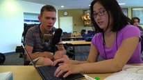
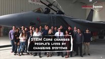
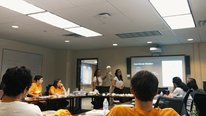
Thank you for taking a look at the video for our UASTEP project. Our video focuses on how our project broadens participation and promotes interest in unmanned aircraft systems (or drones) by creating formal and informal educational opportunities for students, educators, and members of the general public. We partner with industrial professionals and veterans to co-develop our project curriculum, offer internship/employment opportunities, and assess our project activities. We are especially interested in discussions about sustaining collaborations with industry partners, and staying current with this rapidly changing technology.
Dave Miller
Intriguing connections to community collaborations. The career aspect is also a huge value add. I'm interested in seeing what the PD looks like - wondering if that's posted on your linked project page. Thanks!
Wing Cheung
Professor
Hello Dave, thank your the feedback. You can access the description and participant deliverables from our PD workshops on our project website at http://uastep.org/workshops/
Gerhard Salinger
Retired Program Officer
Engaging students in STEM careers through using small drones is a nice idea. How will you measure success both during the grant period and afterwards.
I live in a retirement community undergoing a large expansion project. The noise, dust and general disruption are causing stress among residents. The administration bought a small drone and three residents have learned to use the drone to photograph the construction. These videos are edited and shown on the internal televison station three times a week. One of the residents flies the drone on the same path every week. Eventually this will become a time lapse video of the constrution in that path. Overall, this project has reduced the resident tension inherent in such a disruptive project. Such projects may be usefl in other situations
Wing Cheung
Professor
Great question, Gerhard. During the grant period, we have an external evaluator who surveys and interviews our participants to assess the impact of the project on things like pre-post interest in drone careers and allied fields (e.g. GIS). We have created some infographics of the evaluation results from our summer camps, you can see it on our project website at http://uastep.org/summer-camps/ . We aim to continue using the same suveys after the end of the grant to evaluate our activities.
To your point about video recording of construction projects. We have similar experience with filming construction projects and documenting construction progress on our campus. We have also been asked by the city to do some 3-D models of new construction for their presentation to the city council. We have to be very careful about safety and notifying workers on-site to avoid mishaps.
Mark Bealo
Professor
I wanted to address Gerhard's "small drones" comment just to give a better perspective of some of our fleet and payload capabilities. While we do start beginning students on basic drones to allow them time to get used to the controls and how the aircraft reacts, we quickly move up to more complex drones and projects. Our quad-rotors range from Mavic Airs and Pros to Inspire 2s. In addition we incorporate our Matrice 600 for payloads such as LiDAR and larger cameras. We also have VTOL fixed wing aircraft such as the Quantix Mapper and BirdsEyeView.aero 's FireFLY6. All of our aircraft do fall under the Small Unmanned Aircraft sUAS rating as we are not currently operating anything over 55#s.
Alex DeCiccio
Devon Russell
Awesome project! Getting this technology into the classroom at an early age and providing public outreach helps expand the knowledge and possibilities with UAS.
Wing Cheung
Professor
Thanks!
Mercy Mugo
Senior Research Analyst and Grants Specialist
Exciting project and the partnership is critical in accomplishing greater impact. What challenges have you faced working with multiple partners on the project?
Wing Cheung
Professor
I think limited human resouce is the main challenges faced by our partners. At some of the private consulting firms we have talked to, their main pilot is also their only surveyor or GIS person. So while they want to participate in our project activities, they have limited time to do so. In addition, even though they really need and want interns, they do not have the manpower to train the interns.
Mercy Mugo
Mercy Mugo
Senior Research Analyst and Grants Specialist
Thank you Wing. You mention engaging in community outreach, could you please share what these efforts entail?
Isaac Hernandez
Fantastic work! Excited to see more education investments in UAS technology and continued partnerships with the community and veterans.
Wing Cheung
Professor
Thank you!
Jonathan Beck
Great video Wing, Mark, Michelle and team. Amazing work in cutting edge technologies and paving the way to an exciting future through STEM camps, educator workshop and new program developments.
Michelle Palmer
Wing Cheung
Professor
Thanks Jon!
Jeffrey Ram
Our video included drone footage, the usual outdoor types of views but have you ever seen drone footage from inside a gorgeous unique building? That's how we got the fly through footage inside the Belle Isle Aquarium in our 2020 STEM for ALL Showcase video. Enjoy and keep up the exciting work with your airborne students!
Wing Cheung
David Dickson
Good stuff! I'd love to do something similar at UConn and integrate this into our project. So are you preparing the participants to take the drone operators license test? Also do the students do community projects with the drones? We are just starting to a get drone program off the ground at UConn, but one of the challenges we have found is that flying drones is somewhat the "easier" part. The hard part for us is having folks and equipment who/that can do the post processing and analysis. How do you all deal with that piece?
Wing Cheung
Professor
Hello David. Thank you for your comment. Students in our Certificate/Degree programs are required to take our Part 107 license prep class. But in all of our activities, we require participants to learn about basic safety and regulations. Yes, our summer camps are service learning based. We take the high school students to collect field and drone data to solve specific problems/issues identified by our partnered land conservancies.
Most definitely, the flying part is always the fun part for our participants and students too. Luckily, our school already has an established GIS program, so our GIS and remote sensing classes have been revised to integrate topics like post-processing and analysis. Those classes are also required for the Drone Certificate/Degree.
Mark Bealo
Professor
Continuing on David's question regarding students working on community projects. In the GCIP 268 Digital Imaging with Drones II course we often try to pair students up with new requests we receive or those from established relationships. We've done mapping projects for the City of San Marcos, in California where we are located, to help their GIS staff find the best emergency exit routes in case a fire broke out. We work with SDSU to provide multispectral imagery as well as RGB images of their work in the Santa Margarita Preserve. We've mapped hiking trails for the Fallbrook preserve so they can assess erosion as well as plan for upgrading paved surfaces. We've worked on projects for the City of Temecula to assess cleanup requirements in sections of land with new housing projects planned. All of these types of products give our students real world experience and serve various needs in our community and within industry.
Mark Bealo
Professor
After seeing David's video entry and revising the questions he posted, I think there are a few other items I can add that might provide additional information for you guys.
I'll deal with the equipment and post processing part here. In your conservation and mapping efforts, it is fairly easy to implement an RGB mapping drone such as the DJI Phantom 4 Pro. If you require multispectral imagery or even thermal infrared, that will be a large step up in cost. While there are cheaper ways to go about it, we have chosen the MicaSense Altum payload since it can record RGB, multispectral and Thermal IR all in one mission. But that camera will set you back around $10,000. Plus you need a more substantial drone that can carry the payload. We are using one or our DJI Inspire 2 drones for that purpose. We tried it with our older Inspire 1, but the added weight adversely affected the handling of the drone in the air, so we felt the Inspire 2 would be a safer platform to carry the Altum.
For post processing, I use Agisoft Metashape as it has Linux/Mac/PC versions. Plus the educational pricing is far less than what the main competitor Pix4D costs, and that one is PC only. The full commercial price of Metashape Pro is $3500, but we were able to get 100 educational licenses of the pro version for $140 each.
Your other option, rather than post processing the photogrammetry on your own computers would be to use one of the cloud services such as DroneDeploy. With those types of services you pay a monthly fee and upload images from your drone missions that will be processed in the cloud, and when finished, you can export items such as Ortho's, DTMs and models in GEOTiff, Obj and other formats. We have much more control and far more exports with Metashape Pro or Pix4D, but the processing time can be several hours up to a few days for larger projects. Reach out and contact us if you have additional questions.
Jeremy Roschelle
Director
Hi team,
Your project is exciting -- especially the collaborations with industry, military staff, etc. it left me hungry to know more about the research side. Could you elaborate on what you are learning from other's research that makes your program stronger? And on what you are contributing via research that might make other's programs better?
thanks!
jeremy
Wing Cheung
Professor
Hello Jeremy, thank you for visiting. Our program mainly focuses on education and workforce development, rather than basic research. Most of our research are based on the evaluation of our project activities (conducted by an external evaluator). We mainly summarize and share our results with other projects in the form of "Best Practices" articles and presentations for a range of topics (e.g. starting a UAS program, developing industry-relevant curriculum) in magazines and conferences.
Steven Taylor
What a great idea. So many STEM concepts can be incorporated into learning about a career path that is going to expand as industries begin to see the value in integrating drones into their delivery and imaging systems. I can't wait to see where this project leads students over the next few years. Smart!
Wing Cheung
Professor
Thank you, Steven!
Ashley Pereira
How exciting! I too have found drones to be highly engaging for students. I know your video mentioned summer camps for high school students. I was wondering if there has been any consideration for an online version of the summer camp in light of everything going on right now? I would be interested to learn more. Thank you!
Wing Cheung
Professor
Hello Ashley! Thanks for the question. We have not considered an online option for the summer camp until this pandemic. Mainly because we really wanted to take students out to the field to learn about the environment, and also to give them hands-on practice with flying drones. We can definitely replicate some of the summer camp experience in a virtual environment using simulators and virtual tours, but that may not necessarily meet all of the objectives of our summer camp.
Alex DeCiccio
Cool project with an eye for future career pathways.
Do you offer any of the courses online?
On a separate note, perusing the showcase sparked some ideas after seeing your presentation. Could there be applications for underserved populations in a program like this?
I believe the innovative and seemingly novel career pathways this work could open up may help tie someone’s identity toward future careers with technology and the problems tech can help solve to aspects of their own life. Even applications not though of yet. Has there been any talk about concepts like this in your work?
Awesome collaborations listed in your work and discussion too.
Mark Bealo
Professor
Our Part 107 test prep course, GCIP/GEOG/GEOL 158 Small Unmanned Aircraft Systems Procedures and Regulations, is strictly online. We left off the "underserved" wording in the narration of the video, but the imagery shows the success of our efforts to address those very populations. This is also part of our About statement on the UASTEP.org website "to excite underrepresented high school and college students about UAS educational and career pathways."
Our "Workforce" section under the "Resources" link on the UASTEP site provides heaps of good information and detail about careers and industries incorporating drone technology: http://uastep.org/workforce/
I just saw your video. I narrowed down the ones I was going to review to about 51 based on the target audience of Higher Education Faculty. I guess that is why I missed seeing your entry before I voted. When I saw your title as "Media and Production Specialist" I had to take a look. I teach videography and have been shooting since 8mm film days back when we were kids. Suffice it to say, I viewed your entry with a bit more critical eye. Nice work Alex! That's one I would have voted for. Looks like a rad trip to be on without a doubt!!!
Alex DeCiccio
Alex DeCiccio
Thanks for the response Mark. As you know, and surely this showcase is putting it to the test, media is still one of the best ways of communicating. It fits so well with our basic human need for connection through storytelling.
As for our project, my role was to call each of our 50+ live, multi-camera and bi-directional interactive, programs to connected audiences. To use an analogy, it is kind of like editing within a timeline that cannot stop flowing while everyone is having separate conversations around you, that involve you in different capacities. It is such a blast and an effort I really enjoy participating in. I was actually on our first attempt into the arctic (2018) which ended abruptly when the ship ran aground and we needed to evacuate. Talk about a story!
As for the showcase, if you feel inspired to do so, I do believe votes can be edited. I'll be voting up yours for public choice for sure! I also hold a part 107 license that I acquired in a hurray for a live broadcasting project we did with the BBC a year or so ago. It was an awesome first gig as a drone operator - especially off shore on a research vessel!
Keen to stay in touch and connect later to keep up the convo!
Philip Bell
Thanks for sharing your work. The focus reminded me of a virtual panel I was on when an article came out in the Journal of the Learning Sciences. I wonder if there is an ethical dimension designed into the learning experiences—or if you see the ethical dimensions emerge from students like they did in their engineering ed context? Here's the citation for the piece I'm referring to: Thomas M. Philip, Ayush Gupta, Andrew Elby & Chandra Turpen (2018) Why Ideology Matters for Learning: A Case of Ideological Convergence in an Engineering Ethics Classroom Discussion on Drone Warfare, Journal of the Learning Sciences, 27:2, 183-223, DOI: 10.1080/10508406.2017.1381964
Mark Bealo
Professor
The article you cited references "militarized drones" which we have nothing to do with. Our curriculum is focused on training operators to enter into industry and utilize this emerging technology to incorporate improvements and efficiencies in various careers. For example, in the oil and gas industry, the benefit of using drones provides safer and more efficient maintenance and inspections as well as better data-collection. Roofing inspections have seen a decline in injury and deaths as well as an increase in productivity by incorporating drone technology. Public Safety, Agriculture, Insurance, Real Estate and Filmmaking are all additional industries that have benefited from the use of unmanned aerial systems.
Philip Bell
Thanks for the clarification and the great examples highlighted here. I also know ecological scientists who use drones to gather better data sets. A few years back we worked in a 5th grade context to surface various applications of technology / engineering from a critical sociotechnical frame—which is what cued the question. I wondered if such topics came up in discussions among the students—given the relatively pervasive imagery in movies and media. Students don't always get to learn how the same technologies / designs can be used for all sorts of different purposes coming from different ideological views. But that seems like an important aspect of technological literacy.
Jennifer Carinci
Keep up the great work, Wing, Mark, and Michelle! I love that you have a high school program. What have you found works ell in engaging high school students to go further in STEM?
Michael I. Swart
Great to see a program with focus on applicable skills and vocation. What type of data does this project produce? Can you share any resources about the impact this program is making? Metrics on participation? Curricula? Skills taught? Learned?
With such a useful program, are there plans to create a package that can bring this to more institutions nationwide?